
Wednesday, February 28, 2007
Hopping back to Ushuaia
Just a quick freehander to get back to the jet- thus endeth the side trip. Next, onward- either Buenos Aires or Comodoro Rivadavias. I haven't decided yet.

Saturday, February 24, 2007
Leg the 12th Part V
From The Falklands to Puerto Williams
It's getting to be time to get back to the jet and continue, but I just had to stop by Puerto Williams. They've got a web site, which I ran into while browsing Wikipedia for info on the area. (The Wiki entry is here.)
So, this flight was from Mount Pleasant in the FAlklands to Guardiamenina Zanartu airport at Puero Williams, Chile, just across the channel and up a bit from Ushuaia. Distance was about 380nm, which I flew VFR at 6,500ft, most of the way, until runing into a cloud bank about 90mn out from PW, so I took it up to 8,500. Uneventful strsight in landing- although, it seems that Flight Simulator has a thing for fog & haze at high latitudes. Or at least that's the way the graphics engine interprets 'broken clouds' or 'partly overcast'.
Taking off from Mount Pleasant

Pretty nice weather over the Falklands, apart from the aforementioned haze

Over cloud tops nearing Puerto Williams

Approaching the airport

Taxiing back to the tower bldng.

The actual tower

An aerial phtoi of the city

Overall, it loks like a nice place- very scenic, going to great lengths to attract tourism...

On the other hand- there is this:

It's getting to be time to get back to the jet and continue, but I just had to stop by Puerto Williams. They've got a web site, which I ran into while browsing Wikipedia for info on the area. (The Wiki entry is here.)
So, this flight was from Mount Pleasant in the FAlklands to Guardiamenina Zanartu airport at Puero Williams, Chile, just across the channel and up a bit from Ushuaia. Distance was about 380nm, which I flew VFR at 6,500ft, most of the way, until runing into a cloud bank about 90mn out from PW, so I took it up to 8,500. Uneventful strsight in landing- although, it seems that Flight Simulator has a thing for fog & haze at high latitudes. Or at least that's the way the graphics engine interprets 'broken clouds' or 'partly overcast'.
Taking off from Mount Pleasant

Pretty nice weather over the Falklands, apart from the aforementioned haze

Over cloud tops nearing Puerto Williams

Approaching the airport

Taxiing back to the tower bldng.

The actual tower
An aerial phtoi of the city
Overall, it loks like a nice place- very scenic, going to great lengths to attract tourism...
On the other hand- there is this:
Sunday, February 18, 2007
The Side Trip Continues...
Teniente R Marsh Martin, Antarctica to Mount Pleasant Airport, Falkland Islands
Well, at least Mount Pleasant exists. In Wikiworld, that is. Anyway, it was a great day for VFR, so I took off from Marsh, and headed 600 or so NM up to Mount Pleasant. Here's the trip photos.
Taxiing to the end of the mysterious gravel-on water runway at Marsh
Climbing out of Marsh
Say Goodbye to Antarctica
Nice weather for VFR en route
Low clouds over Mt. Pleasant
Landing in a haze, but still VFR, according to the tower
Aerial Photo of Mount Pleasant
Well, at least Mount Pleasant exists. In Wikiworld, that is. Anyway, it was a great day for VFR, so I took off from Marsh, and headed 600 or so NM up to Mount Pleasant. Here's the trip photos.
Taxiing to the end of the mysterious gravel-on water runway at Marsh

Climbing out of Marsh

Say Goodbye to Antarctica

Nice weather for VFR en route

Low clouds over Mt. Pleasant

Landing in a haze, but still VFR, according to the tower

Aerial Photo of Mount Pleasant

Saturday, February 17, 2007
Coming Back Up
Or, Meandering Back North
I took off from Base Marambio just before dawn- a little before 4:30 am in the middle of summer at this latitude. I had decided to visit some of the other airports in between while coming back north, so I landed at Isla Rey Jorge, and discovered... nothing. A whole lot of nothing. In FS, most of the runway, and in fact the service building, control tower, and beacon are all, uh, offshore. Kinda strange. Satellite photos from both MS and Google don't show anything, and there's no entry that I could find in a Google search, not in Wikipedia. That is a LOT of nothing about some place that ostensibly exists. In fact, there was one item I found that listed it, which was a list of airports that had the airport name and the 4 letter code, but nothing else. Anyway, the screen grabs are kinda cool, if a bit dark. For some reason, the jpegs got darker when uploaded to Blogger.
And, I think I'm going to stick with using 'div' tags and 'br' to format the photos. It seems to work better.
Taxiing out


Ready for Takeoff


Climbing Out


Cruising En Route


Sunrise


Landing


The Mysterious Airport of Watery Spookiness

Saturday, February 10, 2007


Going All The Way Down
From Comodoro Williams Int'l to Base Marambio
I decided to go ahead and 'borrow' a Cessna Grand Caravan to make the flight to Antarctica. After looking at the
charts, I decided that it would be foolish to try to land a 737 anywhere down there,
since the runways are a) a bit short for that and b) gravel. The weight of a 737, even if mostly empty, slamming into a gravel runway doesn't seem like a
recipe for a successful conclusion. So I filed a plan to fly at 7,000 IFR GPS stright shot from Williams to Marambio. After climbing out of the soup, I soon found that 7,000 had me flying through clouds most of the time, so I requested altitude increases until I got above the weather. I wound up cruising at 13,000. The flight took me back and forth over territorial waters of Chile & Argentina, so I switched centers several times, between Punta Arena and Comodoro Rivadaviva. After leaving the Megallanes, the flight was over the Drake Passage until coming into sight of the islands of the Antarctic Peninsula or 'Graham Land'. The base itself is located on Seymour Island, which is on the south side of the peninsula. ATC had me come in on a visual for runway 24- while there is an NDB and a VOR, there's no ILS. The cloud ceiling was at about 3,000, and when I broke through, I was quite surprised to find that the airport is basically a runway set atop a mesa (see photos below). At that point, I was very happy I'd decided not to bring the jet. I blew the approach anyway, and went missed, but landed OK on the next time around.
One note: Comodoro Williams Int'l is the Airport at Ushuaia, not to be confused with Port Williams, which is a town in Chile on the other side of the channel from Ushuaia. Just so you know.
Pardon the space, but I'm experimenting with different methods of getting Blogger to display pictures the way I want to. This was mainly a photo expedition, and I'm trying something new.
Parking at Willimas Int'l |
Holding short |
Getting turned around to line up for takeoff |
Climbout from Williams Int'l |
Climbing thru weather... |
Looking towards Port Williams, above the muck |
Keeping the moon company |
Over Drake Passage |
Approaching Antarctica... |
Over The Antarctic Peninsula |
Approaching the first time around... |
On Final- finally |
A few photos of the real thing: 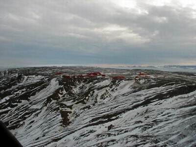 The Control Tower  |
Thursday, February 08, 2007
Leg the 12th Part 1
Im Arsch der Welt
This is a short hop- only about a hundred miles or so. Cruising altitude was 17,000ft, speed 250KIAS. Took off in iffy weather, and landed in thick fog.
Comodor Williams' claim to fame is that it seems to be the farthest south I can get with a 737 for a landing. While there are airports farther south, they're all smaller- which is going to be Part 2, a side trip in a Grand Caravan to look around the outposts and Antarctica.

Climbing out of Punta Arena

En route between Punta Arena and Ushuaia

Approaching in fog

At the End of the World - Comodoro Williams International Airport
Here's what the real thing looks like:

Sunday, February 04, 2007
Leg The Eleventh
Patagonia
I've been remiss with some of my place names- this flight is from Arturo Merino Benitez International Airport, Santiago, Chile to Carlos Ibanez Del Campo International Airport, Punta Arenas (which was actually called Sandy Point by English explorers), Chile. This is arguable the most southern large city, with a 2000 population of 120,000, but its claim to be the southernmost city is, I think, counterfactual. Ushuaia, while smaller, is arguable a city, having a population of 62,000.
In any even, I pushed back at 11:45am, into ground traffic and a dense fog. There were 2 aircraft in line ahead of me for departure, and one behind. Trip distance was about 1170nm. Cruising was at FL330, at 275KIAS.
Radio went from clearance, to ground, to tower, to departure, to Santiago Center. Then it went to Mendoza Center, handing off to Ezeira Center, then after crossing the Argentinian border, Comodoro Rivadavia Center, then crossing back into Chile, Punta Arenas enter, which handed off to the tower. Weather at Carlos Del Campo was rainy, and windy- gusts kept trying to blow my approach off the localizer. Rain stopped minutes after landing, but it was still a dreary day.

Pushing back in the fog at Santiago

Busy Taxiway

Climbing thru the fog

Above the muck, the weather's nice

Approaching between cloud layers at Punta Arena

On final in the rain

Overcast at the airport

Sat. view of the airport

Sat. view zoomed out to show how far the airport is from the city
Subscribe to:
Posts (Atom)
